
Introduction
At least once a week we take the 20 minute train ride into Lisbon. For most of the way in, the train follows the coastline. For the first few minutes, we can look out over the Atlantic Ocean. Then the track goes around a bend at the Praia da Torre – the Tower Beach – and we begin to move up the Tagus River. As we approach the city, the inland landscape changes from apartment complexes to commercial buildings. Along the riverfront are marinas, parks, and wide walkways that on weekend mornings now are filled with joggers, cyclists, tourists, and families pushing prams.
We know we’re close to the city when we can see the Torre de Belém – the Tower of Belém, a 16th Century tower and fortress. It is said that the Torre was the last thing that Portuguese sailors saw as they left Lisbon to explore the world, and the first thing they saw as they returned.

The Monument To The Discoveries
About 1,000 meters further is one of the most interesting monuments we’ve seen in Lisbon – the Padrão dos Descobrimentos – the Monument to the Discoveries.
Historical note:
A padrão is a stone pillar left by Portuguese maritime explorers to mark significant landfalls and claim possession of territory. They were often placed on promontories and capes or at the mouths of major rivers.

The Padrão dos Descobrimentos is an impressive sight. At 56m (184ft) tall, 20m (66ft) wide and 46m (151ft) long, it is a massive structure that suggests the prow of a sailing ship with three billowing sails. It seems ready to launch into the river and out to the vast ocean beyond.


The Monument was originally built in 1940 for the Exposição do Mundo Português, the Portuguese World Exhibition. As first built, it was a molded sculpture made of plaster and burlap on a light iron and cement frame. It was dismantled in 1943. Two decades later it was rebuilt in its current form, to mark 500 years since the death of Prince Henry the Navigator. It is built of concrete and rose-tinted stone from Leiria, about 150km north of Lisbon. The sculptures are carved from limestone from nearby Sintra.
Prince Henry, or Infante Dom Henrique, was the driving force behind many of the Portuguese explorations. On the monument, he stands at the front.

Behind him,on each side of the monument, are statues of important figures of the day, including explorers (Eanes, Dias, da Gama, and others), crusaders, monks, map makers, writers and poets. The one woman in the group is Queen Felipa of Lancaster, Prince Henry’s mother.
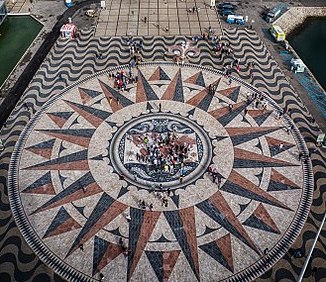
Behind the monument is a large plaza with a limestone mosaic that was a gift from the government of South Africa. It has a Rosa-dos-Ventos (compass rose) that is 50m / 160ft in diameter. In the center is a mappa mundi (medieval map) that shows the routes of Portuguese explorers during the Age of Discovery.
A stairway at the rear of the monument leads to the interior, where there is an auditorium, two exhibition halls, and several meeting rooms. An elevator and stairs lead to the top of the monument. From there you get great views of the Tagus River, the Torre Belém, the Mosteiro dos Jerónimos (Jerónimos Monastery), and the neighborhoods of Belém.


It cost us €5 each to go to the top of the monument. I enjoyed the view. Mary doesn’t care for high places, but came along anyway.
What Was The “Age of Discoveries”?
We live in a time of rapid technological change, with new inventions and knowledge appearing every day. But imagine if you lived in a different time when new knowledge fundamentally changed the view of the world. One such period is the Age of Discoveries. From the 15th to the 17th century, European navigators took exploratory sea voyages and literally redrew the map of the world. Portugal was at the forefront of these activities.
A major impetus for the explorations was commerce – the spice trade. At the time, there were two main routes for importing spices from the far east. On was over land from China. Most of those goods came in through Italy, where the Venetians and the Genovese developed a monopoly on the products. The second route was across the Indian Ocean to Africa, then over land. Muslim traders in northern Africa controlled those routes. The Portuguese wanted to find an alternate route – by sea around Africa – so they could take part in the lucrative trade.
Finding that route took several hundred years and was, in some ways, the 15th century equivalent of the 20th century effort to put a man on the moon. Sailing around the world required better ships, better navigational instruments, and better maps. It also required incredible bravery and stamina. In the early 1400’s, there was a commonly held belief that the outer regions of the Atlantic Ocean held sea monsters, whirlpools that would swallow ships, and boiling waters that no human could survive.
The Monument to the Discoveries immortalizes some of the people who made significant contributions. It’s a “Who’s Who” of Portuguese maritime exploration.
A few of the people on the monument
Infante Dom Henrique – Prince Henry (1394 – 1460)
Prince Henry, known today as “Prince Henry the Navigator”, was the fourth son of King João I. Henry became a royal patron and the sponsor of many early Portuguese exploration.
In 1415, Henry, his father, and his brothers led a fleet of 200 ships to conquer the Moroccan city of Ceuta. After that, he used his power, the resources of the kingdom, and profits from the voyages to advance the knowledge and science of ocean navigation. He sponsored numerous explorations, directing each one to go as far as it could, to map the coast of Africa or any islands, and return.
Under Henry’s patronage, the technology for navigation was dramatically improved. He championed the use of tools like the astrolabe that allowed sea captains to more precisely determine their location. He hired the best cartographers of the time to draw maps based on the explorers’ findings. As a result, Portuguese maps were the best in Europe, and were treated as state secrets to prevent them from falling into the hands of Spanish or Italian spies.
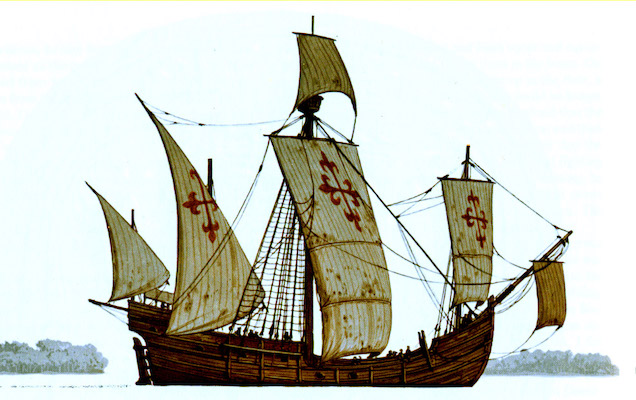
On the Monument, Henry is holding a caravel, a type of ship that made long sea voyages possible.
Historical note:
Caravels had been around for hundreds of years, mostly used for fishing and close-to-shore activities. They were small and very maneuverable. The Portuguese added triangular sails, called lanteens, that allowed the ships to sail in cross winds and headwinds. A later addition of large rectangular sails gave more power and speed when sailing with the wind. Two of Christopher Columbus’ ships – the Niña and the Pinta – are thought to have been caravels.
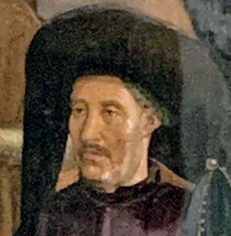
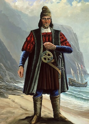
Gil Eanes (1395 – ?)
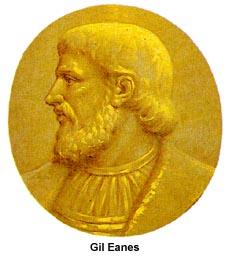
Gil Eanes was a household servant of Prince Henry who progressed through the ranks to become a ship captain. He was the first European to sail around Cape Bojador on the west African coast.
Image Source: web.archive.org
Cape Bojador had been considered impassable and was regarded by most sailors as the edge of the known world. The coast there had a desolate appearance, the waters were often red, discolored by sand blown from the desert. The currents were challenging, with heavy swells.
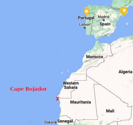
It took Eanes multiple attempts, during two separate expeditions, but in 1434 he was ultimately successful and found calm waters on the other side of the cape.
Eanes is also the namesake for Gil, the mascot of the Exposição Internacional de Lisboa de 1998, or Expo 98. We saw his figure when we visited the Parque das Nações recently.
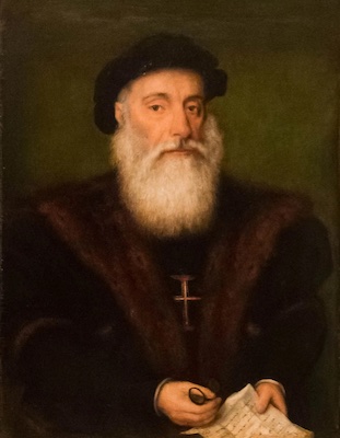
Bartholomeu Dias (1450 – 1500)
In 1488, Bartholomeu Dias became the first European to sail around the southern tip of the African continent, which he named the point the Cape of Good Hope.
Image Source: britannica.com
Because of strong storms, he was sailing out of sight of land, and only saw the cape as he returned. Dias had gone further east in hopes of finding a route to India, but strong currents and discord among his crew caused him to turn back and return to Portugal.
In later life, Dias oversaw construction of two of the ships used for Vasco da Gama’s expedition to India. He also was a member of an expedition that landed on the coast of Brazil in April, 1500.
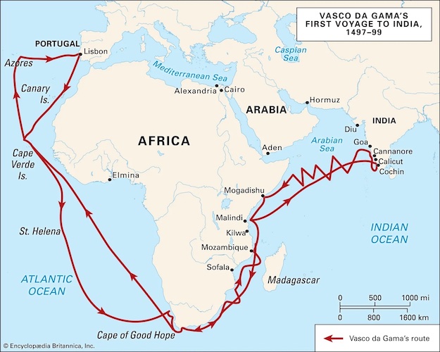
Vasco da Gama (1460 – 1524)
Vasco da Gama was not a navigator, he was more of a political appointee when King Manuel I named him to lead an expedition to India.
Image Source: Daniel Villafruela Creative Commons Legal Code
In July, 1497, Vasco da Gama left Lisbon on an expedition to sail around Africa to India. He arrived at Calicut on the southwest coast of India in May of 1498. Later, Da Gama made two more voyages to india and in 1524 he was named the Portuguese viceroy in India. His voyages finally led to the opening of lucrative trade routes to India and the rest of Asia.
If you’re interested in knowing more about the other people shown on the monument, this brochure has an index.
There Is Always More To Learn
Our visit to the Padrão dos Descobrimentos inspired me to learn more about the history of Portuguese exploration during the Age of Discoveries. I’ve only scratched the surface so far, and my descriptions here omit many significant details. One dark example: A part of the “trade” that was established as a result of these voyages was the trans-Atlantic slave trade. Portugal had a key role in populating plantations in Europe, the Americas, and the Caribbean with enslaved Africans. Today, many Portuguese citizens of African descent are calling for a rethinking of history and recognition of the victims.
More on that another day.
Until next week / Até a próxima semana
Mike
The Writer
What new discovery have you made this week? Tell your tale in the comments below or with a note via the Contact Us form.
Very interesting history…after reading your post I do remember some of the monuments I saw on my visit to Lisbon. Looks like you are really exploring the best of Portugal and enjoying new things every week. More fun adventures ahead! Love, Sue & Eddie
Thanks for the history lesson of Portugal sailing/sailors. I’m sure I knew some of it when visiting Lisbon and other parts of Portugal, but had forgotten. I do remember that huge monument though. Impressive.
This is an especially interesting post. I look forward to returning to Lisbon and seeing these things for myself. If you two were so inclined, you could start lucrative second careers as tour guides. You already have a wealth of knowledge to share.
Take care and thank you for letting us share in the wonder of your amazing lives.
Xo,
Nan
Great read, thanks again for allowing us to share your adventures.